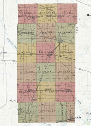
About one year ago, I shared a map that I had put together using a 1929 plat map. This summer, I’ve done it again! (Click here to see the whole interactive map!) This is a map from DeKalb County, Illinois in 1905. Like the previous map, I overlaid scanned, historical maps from a 1905 plat atlas onto a modern map. It’s amazing what you can discover if you look closely at these maps!
I was again able to locate my ancestors more easily on this interactive GIS map. I found my great-great-grandfather Gustaf Medine, living on the first farm that he purchased in Mayfield Township. He was living just one farm away from his brother Peter, and his farm neighbored the farm that he eventually purchased a few years later from Ira Douglas. Other ancestors lived in DeKalb city at that time, and although I don’t know their exact addresses, I can get a better understand of their part of town by looking at the main roads, businesses and churches nearby. I also zoomed into the towns and cities to see how they looked 113 years ago. The small towns in the county were beginning to establish themselves and to grow in 1905. My little hometown hasn’t grown much since then!

This map project was a little more challenging than the first, because the digitized plat map that I used was incomplete. The original maps were from the “Standard atlas of De Kalb county, Illinois, including a plat book of the villages, cities, and townships of the county,” published in 1905 by Geo. A. Ogle & Co., Chicago, IL. The scanned images were from the University of Illinois Digital Collection. Some gaps in the town and city maps are due to these maps covering more than one page, and some parts of the map were lost in the spine of the book when scanning. Also, their original atlas was missing the map for Sycamore Township, so this map was graciously provided by the DeKalb Public Library, DeKalb, IL. Even with some bits missing from the overall map, it is wonderful to get a snapshot of the whole of DeKalb County in 1905!
If your ancestors lived in DeKalb County in 1905, where were they living?

This is so cool. I want to do this for some of my Pittsylvania Co, Virginia ancestors.
LikeLike
Thanks! I really want to do it for all my ancestors, and I only wish that I had the time!
LikeLike
Great work, EvaAnne. I love using maps, especially the old ones with the names of property owners on them. I’ve never created a map like this but a few years ago I combined a county map with a Historical Map Works map, then Google Earth, and found the home of one of g-g-grandfathers from the early 1800s. It would be fun to create a map like this for the locations where some of my ancestors lived.
LikeLiked by 1 person